The ASPRS UAS Technical Demonstration and Symposium preliminary program can now be viewed or downloaded (Full and SHORT versions) on the Conference Program page. A full event agenda including speakers, sessions, and exhibitor information is available.
Tag Archives: UAS
Conference Registration Now Available for Attendees and Exhibitors
Conference registration is now available for all attendees and exhibitors of the ASPRS UAS Technical Demonstration and Symposium. Registration has been consolidated into one easy-to-use link for all registrants.
Additionally, there is a new Exhibitor Registration page dedicated to providing exhibitors all of the necessary information about the conference.
A Brief Note from the Symposium Chair
![]() Good news – the Program Management Office in Nevada indicates strong optimism that the COAs for the live flight demos will be approved. The live flights will utilize the new test course to be established at the test site in conjunction with this symposium. The surveyed test course will remain to be utilized for ongoing UAS testing and quality control.
Good news – the Program Management Office in Nevada indicates strong optimism that the COAs for the live flight demos will be approved. The live flights will utilize the new test course to be established at the test site in conjunction with this symposium. The surveyed test course will remain to be utilized for ongoing UAS testing and quality control.
See you in Reno!
Becky Morton
Symposium Chair
SenseFly’s New eBee Mapping Drone has Built-in RTK
 Sensefly’s eBee RTK could be a game-changer. Jean-Christophe Zufferey, C.E.O. of senseFly claims “The eBee RTK offers surveying and engineering professionals the very highest positional accuracy, without the need for ground control points.” From flight planning to post processing (including GNSS corrections), the system is designed to be a complete out-of-the-box solution.
SenseFly’s 3 reasons to choose the eBee RTK:
- Survey-grade accuracy – Accuracy of 3 cm without the need for GCPs
- Fully integrated workflow – eBee’s flight planning and control software eliminate the need of third-party software
- Compatible with existing base stations – The eBee RTK is compatible with most leading brands of base station, working seamlessly alongside a surveyor’s existing portfolio of instruments.
Availability and pre-order information can be found at senseFLy’s website.
First Civil Aviation Drone Test Flight this Summer in Nevada
 Beginning this summer, the skies in rural Nevada will be filled with identifiable flying objects. Drones, or unmanned aerial vehicles will take flight in Nevada as part of the FAA’s effort of testing the new technology.
“Nevada’s FAA test sites are officially open for business,” said Steve Hill, director of the Governor’s Office of Economic Development, which has spearheaded the state’s efforts to become a test site, the first step in gradually opening U.S. airspace to unmanned aerial vehicles.
The ASPRS UAS Technical Symposium and Demonstration is a UAS conference that will integrate an FAA designated test site into its program.
Nevada Gets a Head Start on Drone Technology
 The state of Nevada has a head start over most areas in the country. The expected $900 billion dollar UAS industry could create thousands of jobs.
“David Strohm is the director of operations for Sensurion. The company makes unmanned-aerial vehicles or UAV’s, commonly referred to as drones. The unmanned-aerial system is the natural evolution, and we have to embrace it,” Strohm said, “Detect and avoid is something the FAA wants.”
Dozens of companies have already lined up to participate in testing for the FAA and hundreds more are interested. “The goal is to make Nevada the cornerstone of the UAV industry, and we are well on our way to doing that,” said James Fleitz from Bowhead.
The ASPRS UAS Technical Symposium and Demonstration is a UAS conference that will integrate an FAA designated test site into its program.
ASPRS
 What is ASPRS?
Founded in 1934, the American Society for Photogrammetry and Remote Sensing (ASPRS) is a scientific association serving over 7,000 professional members around the world. Our mission is to advance knowledge and improve understanding of mapping sciences to promote the responsible applications of photogrammetry, remote sensing, geographic information systems (GIS), and supporting technologies.
ASPRS: The Imaging and Geospatial Information Society
The American Society for Photogrammetry and Remote Sensing (ASPRS) has officially incorporated the tag line “The Imaging and Geospatial Information Society,” as part of the ASPRS identity. This tagline is representative of the Society’s “New Vision,” as it makes the changes necessary to better position its focus for the future.
In announcing this action, ASPRS President Tom Lillesand pointed out that, “Our Board of Directors took unanimous action to adopt a tag line on March 31, 1998 at the Society’s annual meeting. Subsequent to the annual meeting, the Board thoroughly considered alternatives and explored the legal implications of this action. The intent is to preserve the legal name of the Society while providing a better expression of who we are and what we do as an organization.”
“We are extremely proud of our historical roots in imaging science and technology in the form of photogrammetry and remote sensing, and we intend to maintain and build upon our emphasis in this area. However, our membership is focused on imaging not only in the sense of primary data acquisition, but also with respect to the extraction of information from image data in a decision support context,” said Lillesand. “We want to make clear that ASPRS represents a scientific and professional home for a broad array of individuals whose interests span the entire spectrum of geospatial information sciences, technologies, and applications.”
Lillesand stated that “The new tag line is an important expression of ASPRS’s vision for the future. We are attempting to move geospatial information science, technology, and application forward as a holistic enterprise – one that recognizes the interdependence among the academic, public, and private sectors in this whole arena. We want to simultaneously maximize the scientific, societal, and commercial benefits to be realized from geospatial information into the next century. We believe our new tag line helps express the breadth of this vision.”
Who are our members?
ASPRS members-individuals from private industry, the government, and academia are analysts/specialists, educators, engineers, managers/administrators, manufacturers/product developers, operators, technicians, trainees, marketers, and scientists/researchers. Employed in the disciplines of the mapping sciences, our members work in the fields of Agriculture/Soils, Archeology, Biology, Cartography, Ecology, Environment, Forestry/Range, Geodesy, Geography, Geology, Hydrology/water Resources, Land Appraisal/Real Estate, Medicine, Transportation, and Urban Planning/Development.
WHAT ARE THE BENEFITS OF BEING AN ASPRS MEMBER?
- 12-month subscription to Photogrammetric Engineering & Remote Sensing (PE&RS), the official peer-reviewed journal of ASPRS
- Professional Certification
- Networking Opportunities
- 25%-40% Discounts on ASPRS Publications
- Discounts on all ASPRS Conferences (Annual and Specialty)
- Access to National Job Fairs
- Invitations to Technical Committee and Division Meetings
- Invitations to Region specialty conferences, technical tours, workshops, and social activities
- Eligibility for over $18,000 in National and Regional awards, scholarships, and fellowships.
- Opportunity to enroll in group insurance programs (Life Insurance, Dental Plan and Cancer Expense Plan).
Definitions
Photogrammetry is the art, science, and technology of obtaining reliable information about physical objects and the environment, through processes of recording, measuring, and interpreting images and patterns of electromagnetic radiant energy and other phenomena.
Remote Sensing techniques are used to gather and process information about an object without direct physical contact.
Geographic Information System (GIS) is an information system able to encode, store, transform, analyze, and display geospatial information.
To find out more about ASPRS, contact us at:
ASPRS: The Imaging and Geospatial Information Society
5410 Grosvenor Lane, Suite 210
Bethesda MD 20814-2160
tel: 301-493-0290;
fax: 301-493-0208;
or visit our home page at
http://www.asprs.org
Hotel Information
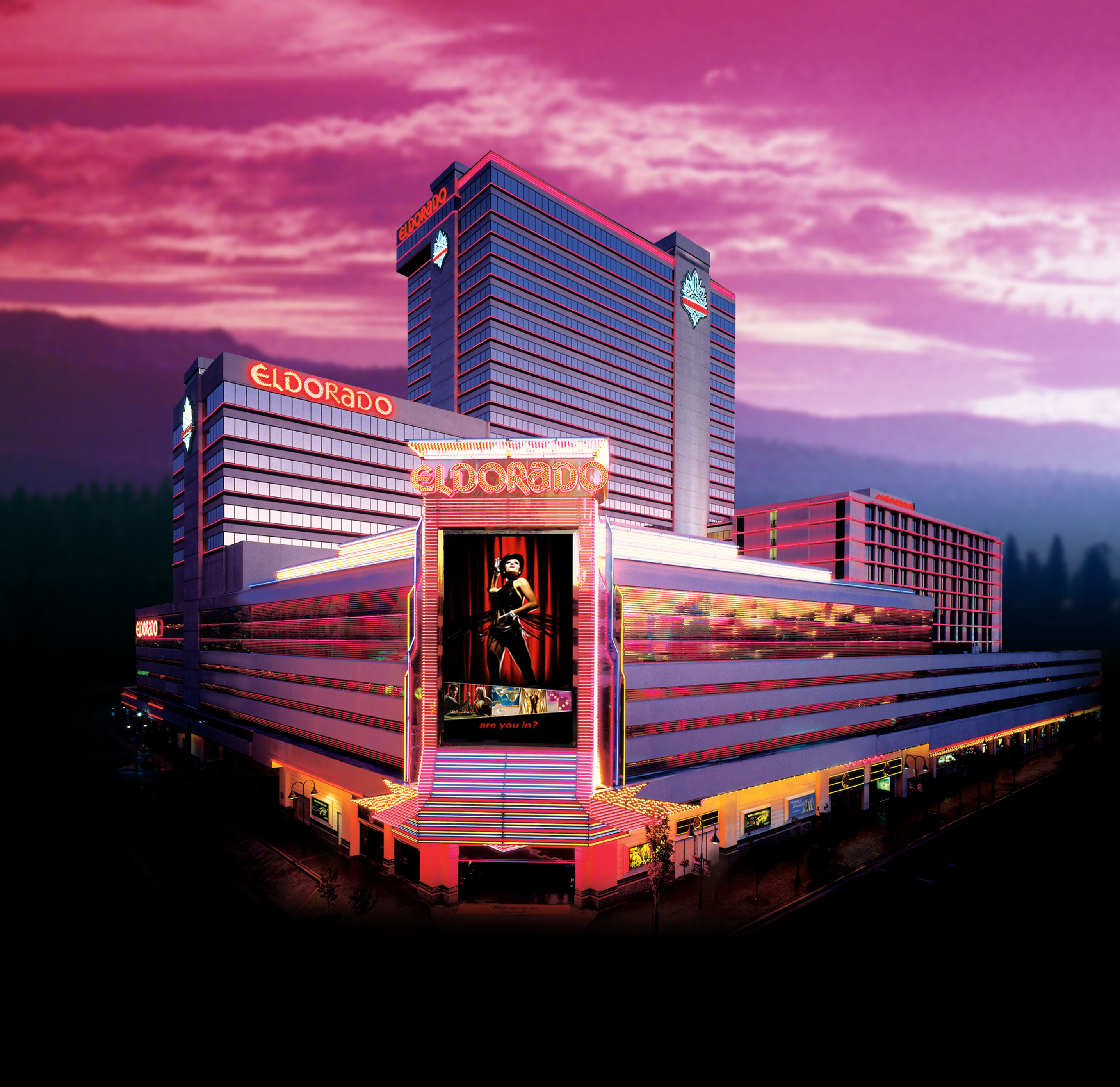 Experience Luxury at Downtown Reno’s Resort Casino Eldorado Reno!
Relax in one the newly remodeled luxurious hotel rooms and suites. New Rooms feature sleek, high-quality furniture in rich, dark woods; all new eye-catching lighting to brighten the overall ambience; new carpet in a striking black and gold pattern that adds a modern flair; and plush side chairs to add an extra touch of warmth to the fresh new style. King rooms now have a sleeper sofa for added comfort and convenience. The rooms also feature fine linen bedding with triple sheeting, HD televisions and ergonomically designed desks with a convenient data port for charging personal electronic devices.
Experience timeless luxury and friendly, personal service in the heart of Downtown Reno. Escape to the Eldorado Resort Casino, named “Best Rooms and Suites” by Casino Player Magazine, where every detail has been considered in order to provide you with the stay of a lifetime. Lose yourself in the nonstop excitement and elegance of the luxurious Reno resort casino. Choose from nine award-winning Reno restaurants, including the world-renowned La Strada and Roxy. Dine on homemade pasta from the in house pasta shop, delicious baked goods made fresh daily in the bakery or checkout a Broadway-style performance in the heart of Downtown Reno in the showroom.
Conference Rates
| Room Type | Sun 10/19 | Mon 10/20 | Tues 10/21 | Wed 10/22 |
| Tower/Deluxe Room Rate | $55.99 | $55.99 | $55.99 | $55.99 |
| Luxury Room Rate | $65.99 | $65.99 | $65.99 | $65.99 |
To receive the discounted conference rate, please call the Eldorado’s group reservations department at 800-648-5966 and use the special group code YASPRS.
Please book by midnight on Friday, September 19,2014. Reservations received after this date will only be accepted on a space and rate availability basis.
Hotel Location
The Eldorado Resort Casino is located just minutes from the Reno-Tahoe International Airport.
From I80:
- Take exit 13 toward Downtown Reno
- Turn south on N Virginia St
From From the Reno-Tahoe International Airport:
- Take US-395 N towards I-80/Reno/Sparks/Truckee
- Merge onto I-80 W
- Take exit 13 toward Downtown Reno
- Turn south on N Virginia St
Conference Program
UAS MAPPING 2014 RENO – PRELIMINARY PROGRAM
| DATE | EVENT | START | END | COMMENT |
| Monday-10/20/14 | ||||
| Exhibition Setup | Noon | 5:00 PM | Reno Ballroom | |
| Registration | Noon | 5:00 PM | Reno Ballroom | |
| Workshops | El Dorado Hotel. Multi-vendor user groups and workshops (unlimited space) | |||
| Welcoming Reception | BuBinga Lounge (El Dorado hotel) | |||
| Tuesday-10/21/14 | ||||
| Registration | 7:00 PM | 5:00 PM | Registration | |
| INTRODUCTORY REMARKS | 8:00 AM | 9:00 AM | ||
| Lewis Graham of GeoCue – Master of Ceremonies | ||||
| Welcoming remarks from State/Reno Officials | ||||
| Mike Hauck, ASPRS Executive Director | Keynote introduction to ASPRS – “Whats at Stake?” | |||
| Stewart Walker, ASPRS President | Words from the ASPRS President – Role of ASPRS in UAV | |||
| Pierrele Roux, ASPRS Division Director | ASPRS Division Activities and Call for participation | |||
| KEYNOTE | 9:00 AM | 9:45 AM | ||
| Keynote Speaker – To be Announced | Talk focused on “why now?” Why are drones suddenly so popular when flying model aircraft have been around for 75 years? Is it the advent of micro-INS that allows an autopilot on a multi-copter? Is it miniaturized cameras? Certainly for our field of geometrically accurate mapping, the development of Structure from Motion (SfM) algorithms has totally changed the market…. | |||
| Break & Exhit Time | 9:45 AM | 10:30 AM | Break/Exhibits | |
| OVERVIEW | 10:30 AM | 11:30 AM | ||
| Invited speaker from the Nevada Test Site – to be announced | UAS testing at the NV Test Site/FAA Regulations/What’s coming up at the test site? | |||
| Introductory talk – speaker to be announced | Introductory talk on the complete workflow from mission planning to creating products. |
|||
| Invited speaker – to be announced | Overview of the economics. What does flying a stockpile with a sUAS do to the price point for this work? Is this really an economic game changer? What are the practical limits of a sUAS project – when is a project just too big? |
|||
| LUNCH & Exhibits | 11:30 AM | 1:00 PM | Lunch in the Exhibit Hall | |
| PANEL 1 – Vehicles | 1:00 PM | 1:45 PM | ||
| Various panelists – to be announced | Panel discussion on the pros and cons of various vehicle types from the perspective of mapping missions – Fixed wing gliders, flying wings and multirotors. |
|||
| Buses to Stead Airport | 3:00 PM | 5:00 PM | Live Demonstrations of UAS in flight at the Stead Airport, north of Reno | |
| Buses from Stead to Hotel | 5:00 PM | 5:30 PM | ||
| Networking Social | 6:00 PM | 7:30 PM | Exhibit Hall | |
| Wednesday-10/22/14 | ||||
| Registration | 7:00 AM | 10:00 AM | Registration | |
| Breakfast in Exhibit Hall | 7:00 AM | 8:30 AM | Exhibit Hall | |
| PANEL 2 – Sensors | 8:30 AM | 9:15 AM | ||
| Various panelist – to be announced | Panel discussing the merits/tradeoffs of cameras and sensors for sUAS. Is a NEX better than a Canon S100? Is there any true advantage of using a metric camera? Some realities of processing when one might subsample images to have point matching run in a reasonable time and does this affect camera choice? Building an NIR camera from a consumer Canon for less than $1,000 and so forth. |
|||
| SESSION: DATA COLLECTION (MISSION PLANNING, GROUND CONTROL, FLYING THE MISSION) Speakers to be announced | 9:15 AM | 10:00 AM | Series of three papers – mission planning, flying the mission, field checking | |
| Break | 10:00 AM | 10:30 AM | ||
| SESSION: DATA PROCESSING AND ACCURACY ASSESSMENT Speakers to be announced | 10:30 AM | 11:15 AM | Series of three papers – Processing workflow/Sfm/QC and Accuracy Assessment | |
| PANEL 3: EMERGING TRENDS-UNIVERSITIES University participants to be announced | 11:15 AM | 12:00 PM | Emerging research in UAS | |
| Lunch (on own) | 12:00 PM | 1:00 PM | ||
| SESSION: EMERGING APPLICATIONS & OPPORTUNITIES FOR UAS | 1:00 PM | 2:30 PM | ||
| Precision Agriculture | New and Emerging Development in Precision Ag | |||
| Mining | New and Emerging Development in Mining | |||
| Fire Fighting | NASA Ames, USFS | |||
| Overseas Opportunities | Invited Speakers – to be announced | |||
| CLOSING KEYNOTE | ||||
| Invited High Tech Co. Speaker – to be announced | 2:30 PM | 3:15 PM | What can we expect from the use of drones from the Hi-Tech industry? | |
| Break | 3:15 PM | 3:45 PM | ||
| SESSION: LIVE DEMO RESULTS | Results from the Live Demo flights | |||
| CLOSING REMARKS | 4:30 PM | 5:00 PM | ||
| Exhibit Tear-down | 5:00 PM | 7:00 PM | (Extended to next day – Tear down Wednesday 8:00 AM – Noon) |
Conference Information
![]() ”Change is in the Air”. This is the tagline of our fall symposium, which denotes the excitement and also the angst that goes along with change. We are all reminded daily, from news and conversation, of the advent of the age of the drones and we each react with our own individual excitement, loathing, fear, curiosity, or blend thereof. The topic is definitely popular right now and ASPRS members are smack dab in the middle of the issue, as one of the largest applications of Unmanned Aircraft Systems (UAS) technology will be mapping. One of the key topics of our symposium will be, ”What is at stake?” When disruptive technology such as UAS comes along, we all have a need for education and collaboration.
”Change is in the Air”. This is the tagline of our fall symposium, which denotes the excitement and also the angst that goes along with change. We are all reminded daily, from news and conversation, of the advent of the age of the drones and we each react with our own individual excitement, loathing, fear, curiosity, or blend thereof. The topic is definitely popular right now and ASPRS members are smack dab in the middle of the issue, as one of the largest applications of Unmanned Aircraft Systems (UAS) technology will be mapping. One of the key topics of our symposium will be, ”What is at stake?” When disruptive technology such as UAS comes along, we all have a need for education and collaboration.
The symposium will bring industry experts to speak to the issues relevant to our mapping and remote sensing community. The program will be tailored to cover topics of aircraft design, sensor payload options, flight planning, flying the mission, data processing and product development. Speakers and panels will be selected to provide first-hand information on these issues.
No UAS symposium would be complete without a group of exhibitors offering hands-on opportunities to see the equipment, talk to the experts, and gather contacts for teaming and collaboration. We have extended preliminary invitations to manufacturers of UAS technology and it appears we will have a large group of vendors who make UAS equipment, provide software solutions, provide UAS components, and provide services.
Last, but certainly not least, this symposium is designed in coordination with the Nevada UAS Test Site. The State of Nevada was selected as one of the six national UAS test sites to serve as an arm of the FAA and provide for the safe transition of civilian applications of UAS into the national air space. This unique collaboration of ASPRS and the Nevada Institute of Autonomous Systems will provide the ability for ASPRS to host live flight demonstrations of UAS as part of the symposium and allow ASPRS to establish the course for on-going test flights of UAS.
The symposium will be held October 21-22, 2014. The events will take place at the Reno Ballroom, a beautiful first-class facility in downtown Reno. The El Dorado, our symposium hotel, is located just across the street. Buses will be arranged to take attendees to the Reno Stead Airport for the live UAS demonstrations. All attempts are being made to keep costs at a minimum in order to encourage broad attendance. It is our goal to reach beyond our ASPRS membership to encourage UAS start]ups, entrepreneurs, GIS professionals, government agencies, surveyors, students, potential UAS users, and general enthusiasts to attend.
The symposium planning committee is making great progress and will be releasing a Preliminary Program and Call for Registration soon. For now, please sign up at our pre-registration link.
Change is in the air! Please join us in Reno to explore what is at stake and how to prepare for change!
Becky Morton
ASPRS UAS Symposium Chair

You must be logged in to post a comment.